Файл:Ingushetia topographic map de.png
ЛІэужьыгъуэ нэхъ ин щыӀэкъым.
Ingushetia_topographic_map_de.png (263 × 349 пикселу, файлым и инагъыр: 150 KB, MIME-тип: image/png)
КӀэщӀу зытеухуар
| Зытеухуар |
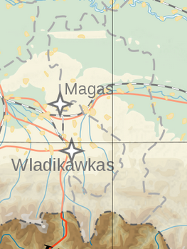
English: Topographic map of Ingushetia.
Deutsch: Topografische Karte Inguschetiens. |
| Махуэр | |
| КъежьапӀэр | Own work by uploader, derivate of File:Georgia topographic map-de.svg |
| Лэжьыгъэр зи Ӏэдакъэ щӀэкӀар | Don-kun |

|
This map image could be re-created using vector graphics as an SVG file. This has several advantages; see Commons:Media for cleanup for more information. If an SVG form of this image is available, please upload it and afterwards replace this template with
{{vector version available|new image name}}.
It is recommended to name the SVG file “Ingushetia topographic map de.svg”—then the template Vector version available (or Vva) does not need the new image name parameter. |
Лэжьыгьэ бгъэзэщӀэну хуит узыщӀ тхылъ
I, the copyright holder of this work, hereby publish it under the following licenses:
Мы файлыр лицензиекӀэ уогъуэт Creative Commons Attribution-Share Alike 3.0 Unported
- Ухуитщ пщӀыну:
- дэгуэшын – Мы лэжьыгъэр тещӀыкӀын, хэӀущІыІу щӀын, зыӀэпыхын
- зэхъуэкӀыжын/зэгъэпэщыжын – лэжьыгъэр щӀэрыщӀэу щӀыжын
- Мы Ӏуэхугъуэхэр бгъэзащӀэмэ:
- атрибуцэ – ТхакӀуэм и цӀэр,лицензиер, тхакӀуэм зэхъуэкӀыныгъэ хилъхьахэр къэбгъэлъэгъуэн хуейщ. Ар сыт хуэдэ къызэрыгуэкӀ Ӏуэхугъуэк1и пщ1ы хъунущ, ауэ лицениер зейм уэ удэщӀу е уэ укъигъэсэбэпу фэ къытеуэн хуейкъым.
- А Ӏуэхугъуэ дыдэхэмкІэ зегъэубгъуныгъэ – Фэ зэфхъуэкӀымэ, зэвгъэзахуэмэ е мыр и лабжьэу нэгъуэщӀ лэжьыгъэ гуэр буухуэмэ оригиналым и лицензиер къэбгъэсэбэбын хуейщ Ӏэмал имыӀэу е е оригиналым езэгъ лицензие.

|
Разрешается копировать, распространять и/или изменять этот документ в соответствии с условиями GNU Free Documentation License версии 1.2 или более поздней, опубликованной Фондом свободного программного обеспечения, без неизменяемых разделов, без текстов, помещаемых на первой и последней обложке. Копия лицензии включена в раздел, озаглавленный GNU Free Documentation License. |
Узыхуей лицензиер къыхэпх хъунущ
Файлым и тхыдэ
Махуэ/зэманым тепӀытӀэ файлыр дапщэщ сыт хуэдэу щытами уеплъынумэ
| Махуэ/Зэман | КӀэщӀу | инагъыр | ЦӀыху хэтыр | Гу зылъытапхъэ | |
|---|---|---|---|---|---|
| иджы екӀуэкӀыр | 01:30, 9 Мэлыжьыхь 2023 | | 263 × 349 (150 KB) | Merjuev Salovdi | Reverted to version as of 19:50, 13 January 2020 (UTC)richtige Grenzen |
| 08:56, 14 ЩӀышылэ 2020 |  | 1,500 × 1,133 (767 KB) | Don-kun | Reverted to version as of 11:27, 20 February 2014 (UTC) version by Takhirgeran Umar didnt highlight ingushetia, but geogia | |
| 22:50, 13 ЩӀышылэ 2020 |  | 263 × 349 (150 KB) | Takhirgeran Umar | clarification | |
| 14:27, 20 Мазае 2014 |  | 1,500 × 1,133 (767 KB) | Don-kun | cor Magas | |
| 14:04, 27 Бадзэуэгъуэ 2009 |  | 1,499 × 1,123 (769 KB) | Don-kun | {{Information |Description={{en|1=Topographic map of Ingushetia. }} {{de|1=Topografische Karte Inguschetiens.}} |Source=Own work by uploader, derivate of File:Georgia topographic map-de.svg |Author=Don-kun |Date=2009-07-27 |Permissio |
Файлыр къэгъэсэбэпын
Мы напэкӀуэцӀыр 1 тохьэ мы файлым:
Куэд къызэщӀиубыдэфыу файлыр къэгъэсэбэпын
Мы файлыр мыпхуэдэ викихэм къыщагъэсэбэп:
- Къыщыгъэсэбэпын azb.wikipedia.org
- Къыщыгъэсэбэпын inh.wikipedia.org