Файл:Ossetian tribes.png
Зэрыщытын формэм и инагъыр: 329 × 599 pixels. нэгъуэщӀ разрешенэхэр: 132 × 240 pixels | 494 × 899 pixels.
Файлым и къежьапӀэр (494 × 899 пикселу, файлым и инагъыр: 47 KB, MIME-тип: image/png)

|
This map image could be re-created using vector graphics as an SVG file. This has several advantages; see Commons:Media for cleanup for more information. If an SVG form of this image is available, please upload it and afterwards replace this template with
{{vector version available|new image name}}.
It is recommended to name the SVG file “Ossetian tribes.svg”—then the template Vector version available (or Vva) does not need the new image name parameter. |
КӀэщӀу зытеухуар
| Зытеухуар |
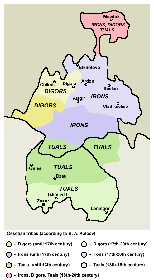
English: Ossetian tribes (according to B. A. Kaloev). |
| Махуэр | |
| КъежьапӀэр | Уней лэжьыгъэр |
| Лэжьыгъэр зи Ӏэдакъэ щӀэкӀар | PANONIAN |
Лэжьыгьэ бгъэзэщӀэну хуит узыщӀ тхылъ
I, the copyright holder of this work, hereby publish it under the following license:
| This file is made available under the Creative Commons CC0 1.0 Universal Public Domain Dedication. | |
| The person who associated a work with this deed has dedicated the work to the public domain by waiving all of their rights to the work worldwide under copyright law, including all related and neighboring rights, to the extent allowed by law. You can copy, modify, distribute and perform the work, even for commercial purposes, all without asking permission.
|
References
Made according to this source:
- http://s50.radikal.ru/i129/1003/22/2fec9d793e3d.jpg archive copy at the Wayback Machine
- https://s23.postimg.org/aze2tqr9n/2fec9d793e3d.jpg
Comparative sources
- map from www.iriston.com: http://www.iriston.com/books/cuciev_-_etno_atlas/maps/map46.jpg (Ethno Atlas, Cuciev), later translated into English by Yale University Press: https://books.google.de/books?id=NHeaAwAAQBAJ&pg=PR11&dq=arthur+tsutsiev+caucasus&hl=de&sa=X&ved=0ahUKEwiaoeK9laPQAhVLPhQKHYq-C8oQ6AEIJjAA#v=onepage&q=arthur%20tsutsiev%20caucasus&f=false
- map from www.aors.narod.ru: http://www.aors.narod.ru/images/Al-VII.gif - the map is linked from this page: http://www.aors.narod.ru/Texty/AlyVII-XII.htm Here is bibliography of this web site: http://www.aors.narod.ru/Texty/Istochniki.htm - history maps probably came from this history atlas listed in bibliography: "Исторический атлас Осетии / Отв. ред. Р.С. Бзаров - Владикавказ: Ремарко, 2002 - 48 с. ил."
Файлым и тхыдэ
Махуэ/зэманым тепӀытӀэ файлыр дапщэщ сыт хуэдэу щытами уеплъынумэ
| Махуэ/Зэман | КӀэщӀу | инагъыр | ЦӀыху хэтыр | Гу зылъытапхъэ | |
|---|---|---|---|---|---|
| иджы екӀуэкӀыр | 20:41, 4 Мазае 2017 | | 494 × 899 (47 KB) | PANONIAN | {{Information |Description ={{en|1=Ossetian tribes (according to B. A. Kaloev).}} |Source =own work |Author =PANONIAN |Date =2017 |Permission = |other_versions = }} |
Файлыр къэгъэсэбэпын
Мы напэкӀуэцӀыр 1 тохьэ мы файлым:
Куэд къызэщӀиубыдэфыу файлыр къэгъэсэбэпын
Мы файлыр мыпхуэдэ викихэм къыщагъэсэбэп:
- Къыщыгъэсэбэпын af.wikipedia.org
- Къыщыгъэсэбэпын an.wikipedia.org
- Къыщыгъэсэбэпын ast.wikipedia.org
- Къыщыгъэсэбэпын av.wikipedia.org
- Къыщыгъэсэбэпын azb.wikipedia.org
- Къыщыгъэсэбэпын az.wikipedia.org
- Къыщыгъэсэбэпын be-tarask.wikipedia.org
- Къыщыгъэсэбэпын be.wikipedia.org
- Къыщыгъэсэбэпын bg.wikipedia.org
- Къыщыгъэсэбэпын bn.wikipedia.org
- Къыщыгъэсэбэпын ca.wikipedia.org
- Къыщыгъэсэбэпын ce.wikipedia.org
- Къыщыгъэсэбэпын cs.wikipedia.org
- Къыщыгъэсэбэпын cy.wikipedia.org
- Къыщыгъэсэбэпын da.wikipedia.org
- Къыщыгъэсэбэпын de.wikipedia.org
- Къыщыгъэсэбэпын diq.wikipedia.org
- Къыщыгъэсэбэпын el.wikipedia.org
- Къыщыгъэсэбэпын en.wikipedia.org
- Къыщыгъэсэбэпын eo.wikipedia.org
- Къыщыгъэсэбэпын es.wikipedia.org
- Къыщыгъэсэбэпын et.wikipedia.org
- Къыщыгъэсэбэпын eu.wikipedia.org
- Къыщыгъэсэбэпын fa.wikipedia.org
- Къыщыгъэсэбэпын fi.wikipedia.org
- Къыщыгъэсэбэпын fr.wikipedia.org
Еплъын глэбальнэу къызэрагъэсэбэп мы файлыр.