Файл:Wfm firth of forth.jpg

Зэрыщытын формэм и инагъыр: 800 × 593 pixels. нэгъуэщӀ разрешенэхэр: 320 × 237 pixels | 640 × 474 pixels | 1,024 × 758 pixels | 1,280 × 948 pixels.
Файлым и къежьапӀэр (1,280 × 948 пикселу, файлым и инагъыр: 289 KB, MIME-тип: image/jpeg)
КӀэщӀу зытеухуар
| Зытеухуар |
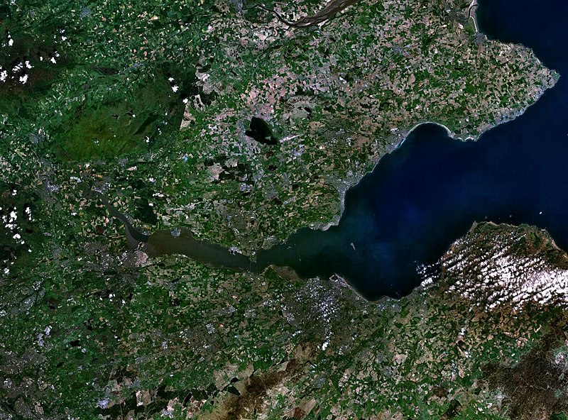
English: The Firth of the river Forth, on the east coast of Scotland. The two forth bridges are visible near the centre of the frame. Stirling is at the extreme left side. |
| Махуэр | 3 ШыщхьэӀу 2005 (upload date) |
| КъежьапӀэр | Satellite imagery taken by screenshot from NASA World Wind software |
| Лэжьыгъэр зи Ӏэдакъэ щӀэкӀар | NASA |
Лэжьыгьэ бгъэзэщӀэну хуит узыщӀ тхылъ
| This image is in the public domain because it is a screenshot from NASA’s globe software World Wind using a public domain layer, such as Blue Marble, MODIS, Landsat, SRTM, USGS or GLOBE.
|
 |
Файлым и тхыдэ
Махуэ/зэманым тепӀытӀэ файлыр дапщэщ сыт хуэдэу щытами уеплъынумэ
| Махуэ/Зэман | КӀэщӀу | инагъыр | ЦӀыху хэтыр | Гу зылъытапхъэ | |
|---|---|---|---|---|---|
| иджы екӀуэкӀыр | 12:38, 3 ШыщхьэӀу 2005 | | 1,280 × 948 (289 KB) | Finlay McWalter | The Firth of the river Forth, on the east coast of Scotland. The two forth bridges are visible near the centre of the frame. Stirling is at the extreme left side. Image made with NASA World Wind. {{PD-USGov-NASA}} category:satellite photos |
Файлыр къэгъэсэбэпын
Мы напэкӀуэцӀыр 1 тохьэ мы файлым:
Куэд къызэщӀиубыдэфыу файлыр къэгъэсэбэпын
Мы файлыр мыпхуэдэ викихэм къыщагъэсэбэп:
- Къыщыгъэсэбэпын ar.wikipedia.org
- Къыщыгъэсэбэпын be.wikipedia.org
- Къыщыгъэсэбэпын bg.wikipedia.org
- Къыщыгъэсэбэпын br.wikipedia.org
- Къыщыгъэсэбэпын ca.wikipedia.org
- Къыщыгъэсэбэпын ceb.wikipedia.org
- Къыщыгъэсэбэпын cs.wikipedia.org
- Къыщыгъэсэбэпын cy.wikipedia.org
- Къыщыгъэсэбэпын de.wikipedia.org
- Къыщыгъэсэбэпын el.wikipedia.org
- Къыщыгъэсэбэпын en.wikipedia.org
- Къыщыгъэсэбэпын en.wikivoyage.org
- Къыщыгъэсэбэпын eo.wikipedia.org
- Къыщыгъэсэбэпын es.wikipedia.org
- Къыщыгъэсэбэпын et.wikipedia.org
- Къыщыгъэсэбэпын eu.wikipedia.org
- Къыщыгъэсэбэпын fa.wikipedia.org
- Къыщыгъэсэбэпын fr.wikipedia.org
- Къыщыгъэсэбэпын ga.wikipedia.org
- Къыщыгъэсэбэпын gd.wikipedia.org
- Къыщыгъэсэбэпын ha.wikipedia.org
- Къыщыгъэсэбэпын he.wikipedia.org
- Къыщыгъэсэбэпын hi.wikipedia.org
- Къыщыгъэсэбэпын ia.wikipedia.org
- Къыщыгъэсэбэпын is.wikipedia.org
- Къыщыгъэсэбэпын it.wikipedia.org
- Къыщыгъэсэбэпын it.wikivoyage.org
- Къыщыгъэсэбэпын ja.wikipedia.org
- Къыщыгъэсэбэпын lt.wikipedia.org
- Къыщыгъэсэбэпын mt.wikipedia.org
- Къыщыгъэсэбэпын nl.wikipedia.org
- Къыщыгъэсэбэпын nn.wikipedia.org
- Къыщыгъэсэбэпын no.wikipedia.org
- Къыщыгъэсэбэпын pl.wikipedia.org
- Къыщыгъэсэбэпын pt.wikipedia.org
- Къыщыгъэсэбэпын ro.wikipedia.org
- Къыщыгъэсэбэпын ru.wikipedia.org
- Къыщыгъэсэбэпын sco.wikipedia.org
Еплъын глэбальнэу къызэрагъэсэбэп мы файлыр.